Vagrant birds and ancient human habitats
People killed the Carolina parakeet. An inquiry into their historic population range helps illustrate the challenges of understanding ancient human populations.

Two hundred years ago, the woods of the eastern U.S. and much of the Midwest were home to noisy flocks of bright green parakeets. The Carolina parakeet became extinct in 1918 when the last known individual died in the Cincinnati Zoo. This ultimate end followed a century of decline.
There's little mystery about the cause. In 1891, Edwin Hasbrouck summarized what was then known about the Carolina parakeet for the journal The Auk. Lamenting the rapid decline, he described the bird's reputation as a crop pest, especially of orchards where the parakeets stripped flowers and buds from trees. He recounted a social habit with tragic consequences: when an individual was injured, others tended to flock close around—making them easy prey for angry farmers. Whether by farmer's shotguns, habitat loss, or disease carried by domestic birds, there's little question that humans were the ultimate agents of the Carolina parakeet's demise. It wasn't hunted for food: Many sources suggest that the bird's preference for eating the toxic cocklebur rendered its flesh unpalatable.
“Nature seems to have implanted in these birds a propensity to destroy, in consequence of which they cut to atoms pieces of wood, books, and, in short, every thing that comes in their way.”
Some time ago, an article in Audubon magazine by Sabrina Imbler told the story of research by Kevin Burgio, Colin Carlson, and Morgan Tingley, in which they examined the case of the Carolina parakeet from a biogeographic perspective. Their scientific article had the fascinating title: “Lazarus ecology”. Their ambition was not to resurrect the extinct bird from DNA, but to use historical records and ecological modeling to determine the real habitat tolerance of this extinct bird, to work out where it had actually lived.
This surprised me. We didn’t know where the Carolina parakeet lived?
The remarkable bird, with bright green bodies and red-capped heads, was one of the most striking of North America. Birders, already growing in numbers by the late nineteenth century, noticed when a parakeet came flying their way. Yet most records date from a period when the species was in rapid decline.
Birdwatchers look at geographic range in a different way from ecologists. Birds fly widely, and you might see a bird somewhere pretty far from where substantial populations of them actually live and breed. A few years ago, birders in the northeast U.S. and Canada were riveted as a Stellar’s sea eagle winged its way along the Maine coast. This species inhabits the northeast coastline of Asia and Hokkaido, Japan—more than 8000 miles away from the town of Boothbay Harbor. Bagging such a rare sighting is a bucket list item for many birders. Last year my own state of Wisconsin had its first sightings of flamingos.
Biologists call such birds vagrants. Vagrant sightings can give valuable information about the dispersal behavior of birds. Under some circumstances, rare sightings can tell biologists a lot about a species’ potential tolerance of new habitats.
But they can be misleading. Vagrants may be reacting to pressures in the areas where most members of their species live — some showing up in unusual places because their species is proliferating, others because their core habitat may be deteriorating. To learn about the long-term survival and evolution of a species, field ecologists need more detailed observations of local population density and breeding. They need to know which habitat the species actually thrives in, not just what it may occasionally tolerate.
It turns out that what researchers had long accepted as the “range” of Carolina parakeets was hazy. The clearest map was drawn by Hasbrouck in his 1891 article, when the species had been reduced to small pockets in Florida and the Oklahoma territory. He took the records of sightings from the 18th and early 19th centuries and drew an outline around the geographic extremes. That map gave the impression that the species was spread across most of the eastern United States.

Burgio, Carlson, and Tingley found that old map was misleading. They went carefully through historical sightings, removing vagrant sightings outside of breeding season. They also set apart sightings of the two different subspecies of Carolina parakeets, which seemed to have come mostly from different regions. One of them was found mostly in the Midwest and Mississippi Valley, the other in Florida and along the Gulf and Atlantic Coasts.
They plugged the historical data points into a model that included data on local temperature, rainfall, and plant cover. The conditions at the locations where the birds were recorded provided a view of the habitats where the species tended to survive and breed. From this, the researchers built a map of where these combinations of conditions existed.

This new map looked very different from the old one. The two subspecies barely overlapped with each other. Each of them preferred a much smaller area than the wide range where people might occasionally see vagrant parakeets. There were small pockets of suitable habitat outside of these core ranges, like the area just around Chicago, but by themselves these could not sustain large populations.
When their core areas were threatened, the parakeets were doomed.
“Our Parakeets are very rapidly diminishing in number; and in some districts, where twenty-five years ago they were plentiful, scarcely any are now to be seen.”
In a way, anthropologists are more like birders than ecologists. We want to find fossils wherever we can, and we’ll record whatever we find. But this haphazard approach means that we can’t rely on maps of fossil discoveries as accurate guides to where ancient hominins lived. Fossil sites have many of the same problems as sightings of vagrant birds.
Humans and our fossil relatives were ancient hunters and gatherers who knew and traveled across extensive landscapes. Within a single year, a group of ancient people may have spent time at sites separated by hundreds of kilometers. In many of the places where they walked, these ancient people were vagrants—just passing through on their way from one core range to another.
For most of the places they visited, evidence of their passing would have disappeared a short time after they left. Stone flakes and discarded tools would persist the longest, but even these were usually scattered by erosion, or picked up again at old campsites and used by later people—an ancient version of recycling. Rarely a site may open a larger window: the extraordinary discovery reported last year in Zambia of notched logs forming the base of an ancient structure shows clearly that hominins invested effort into this place, possibly because they stayed there a long time. But for the most part, the campsites used by ancient hominins were ephemeral.
Caves and rockshelters are honeypots for archaeologists. Sediments sheltered inside them sometimes resist the relentless wear of erosion. They give a fair chance of exposing a few surfaces where the ancients walked or lived. Hominins have used caves for more than three million years, and cave sites provide some of the best evidence of the tools they made and the animals they ate. The dirt may even give a glimpse of plant foods, wooden tools, or wood once gathered for fires. Just as often, a cave is the den of a carnivore, and the only traces of hominins have passed through a gut.
“They are incapable of articulating words, however much care and attention may be bestowed upon their education; and their screams are so disagreeable as to render them at best very indifferent companions.”
The evidence rarely says whether the hominins stayed for long. Were they resident or vagrant? The human relationship with caves around the world is complicated. Some people live happily underground, elaborating natural spaces and constructing their own artificial ones. More often, people make intermittent use of caves, sheltering against enemies or storing things against hard times. Many caves are ritual spaces, places where people carry out ceremonies, leave powerful objects, or talk with other beings. Chimpanzees and other animals likewise use caves sometimes. For primates, they are most often places to escape the heat.
A refuge in hostile conditions is a bad data point for an archaeologist who wants to draw a map of ancient hominins. Caves and rockshelters are likely to be visited by the occasional group of vagrants even in regions where hominins are otherwise sparse. The anthropological problem resembles the unknown range of the Carolina parakeet. Caves and rockshelters may be the richest parts of the deep time archaeological record, but they may not help much in figuring out where hominins actually lived.
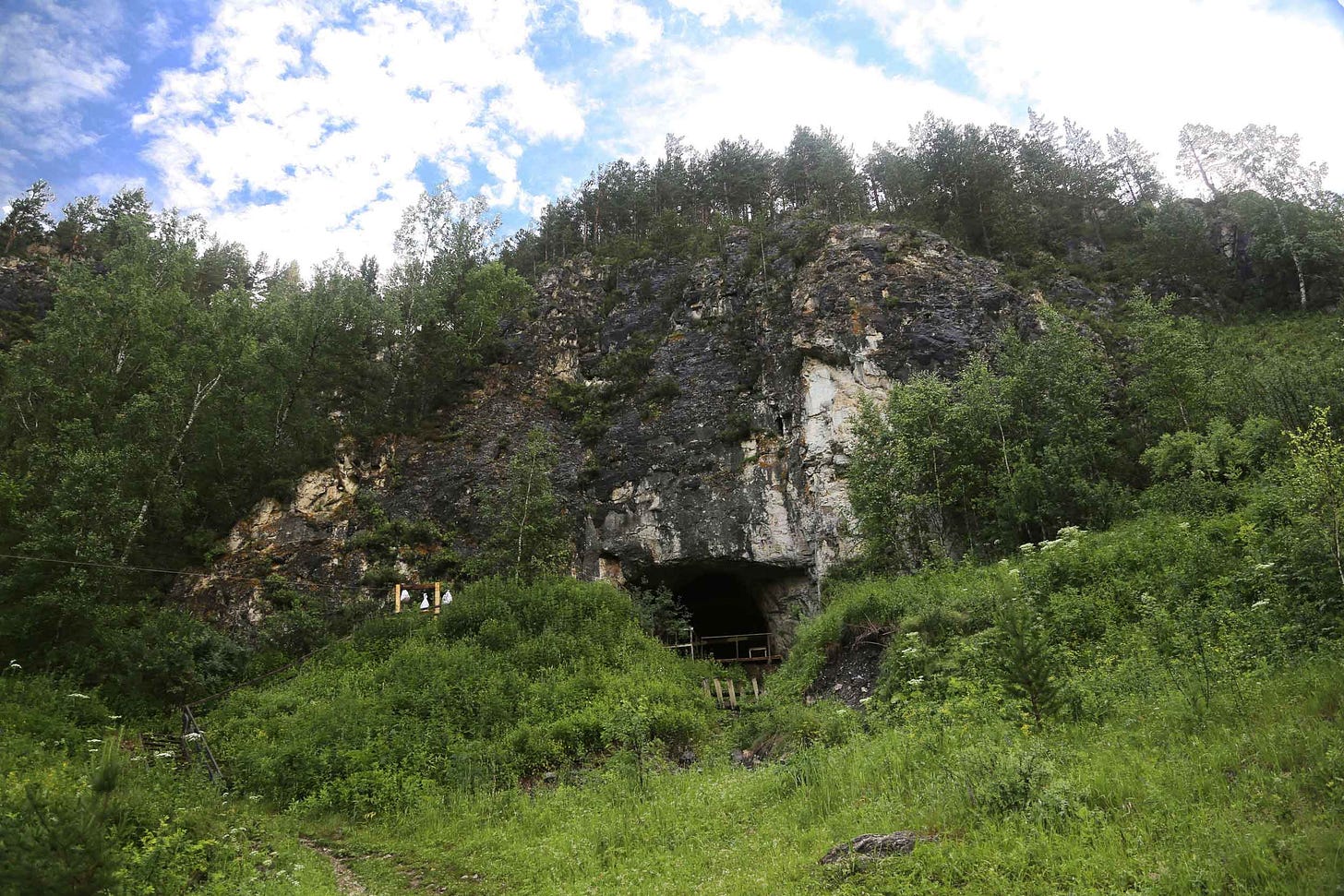
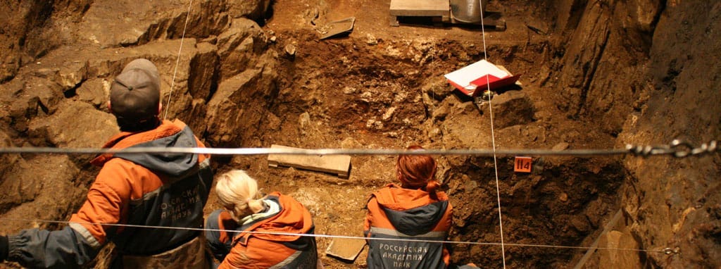
Denisova Cave, in the Altai Mountains of present-day Russia, is one of the most productive sources of evidence about ancient humans from the last 300,000 years. This evidence does not come from whole fossil skeletons or skulls. Archaeologists at Denisova have found only a few teeth and small fragments of bone, almost unrecognizable. The consistently cold temperatures inside the cave have preserved ancient DNA within these bits of bone, enabling geneticists to reconstruct whole genomes of ancient people. The biochemical preservation in the cave enables scientists to sequence short DNA fragments even without visible bone fragments, from bulk samples of sediments. Most is preserved within flakes of bone or feces that are so small they cannot be seen without a microscope.
In the uppermost layers of Denisova Cave, after 45,000 years ago, the sediments contain the DNA of modern people. Earlier, some of the bone fragments and sediment DNA come from Neandertals, a population that we know from many other sites in Europe and western Asia. Other bone fragments and teeth come from a second population, which was entirely unknown before the DNA discoveries began. This group separated from the Neandertals more than 500,000 years ago, and geneticists took to calling them the “Denisovans”. This group has been a powerful focus of anthropological speculation. Biochemical evidence connects them to a jawbone from the Tibetan Plateau and a tooth from Laos, while geneticists working with DNA from living people have identified Denisovan ancestry across Asia and Oceania.
Some sediment layers going back to as early as 300,000 years ago have Denisovan DNA, others have Neandertal DNA, and a few have both kinds of hominins. In 2018, scientists led by Vivian Slon found that one bone fragment from the cave, Denisova 11, comes from an individual with a Neandertal mother and a Denisovan father. This and other genomes show evidence of crossing between the groups in earlier generations.
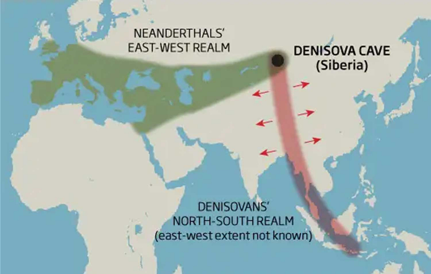
The discovery of Denisovans has given rise to a wild streak of archaeological mapmaking. At first, people who illustrated the geographic range of the unknown population tried to be conservative. The direct evidence came only from Denisova Cave, while indirect evidence based on the DNA ancestry of living people was most evident in Australia, Papua, and the Philippines. So illustrators started with a narrow line connecting these two far-flung locations. For example, this map accompanied an article from New Scientist in 2011:
In retrospect this was an admirable effort not to exceed the data. Illustrators from the major scientific journals, especially Nature Publishing Group, quickly expanded the Denisovan range to encompass the entire eastern half of Eurasia. In every version, Denisova Cave has a central position as the place where two different realms meet.
For example, this map was published with a 2014 review article in Nature Genetics, showing Denisovans from Pakistan to Manchuria, and south into Indonesia.
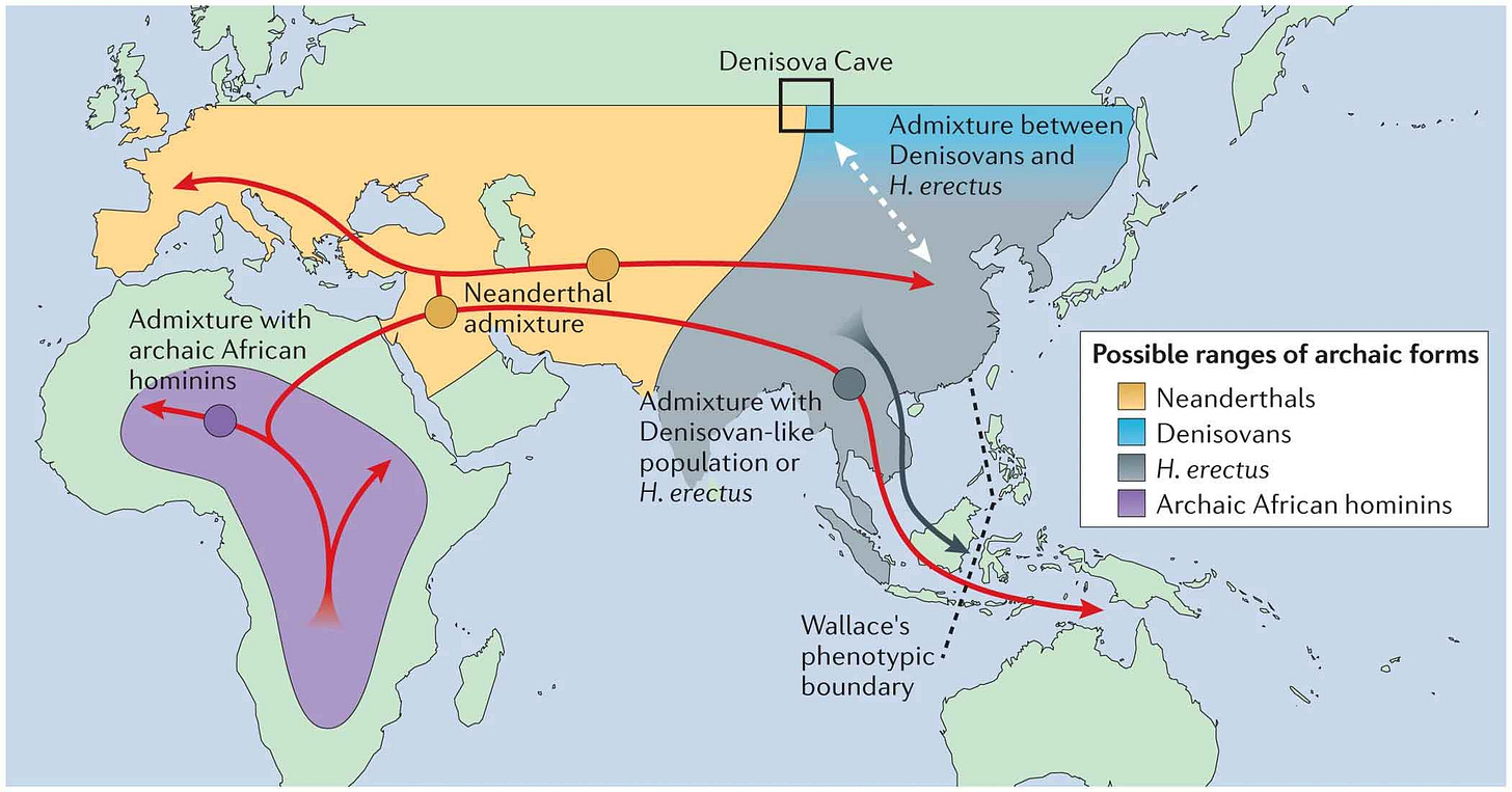
I've often called this the “Napoleonic view” of ancient behavior. The idea is that ancient groups staked out large territories and stayed within their boundaries once established. It's like the Carolina parakeet map drawn by Hasbrouck, just taking the most extreme observations and drawing a big line around them. The obvious question is the same one posed by the Hasbrouck map: How typical are the observations at the edges of the geographic range?
The unfortunate truth is that the Pleistocene archaeological record gives us no way to assess how typical a site may have been for an ancient population. Archaeological data give us little chance of seeing whether such a site was within a core range or periphery. DNA could potentially provide evidence of long-term persistence of a population. In the case of Denisova and nearby sites like Chagyrskaya Cave, that's not what the DNA shows. Instead, Denisova’s history has a Groundhog Day quality: two groups who seem rarely to have met, yet encountering each other again and again.
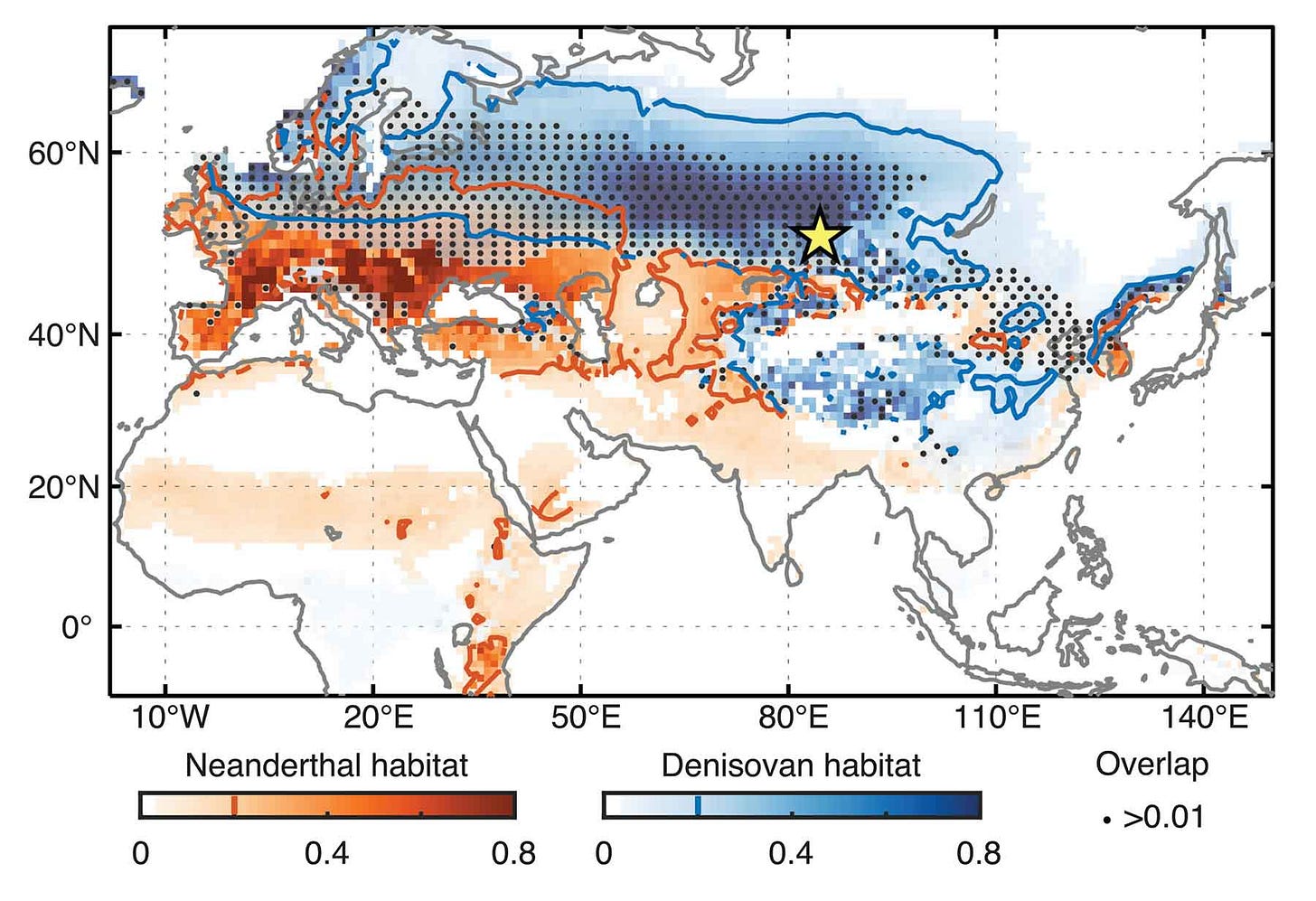
Last year a major study of Neandertal and Denisovan ecology by Jiaoyang Ruan and coworkers went a step further than the earlier maps. Like the Carolina parakeet study by Burgio, Carlson, and Tingley, the new research relied on data about climate and environment to try to work out the habitat preferences of extinct groups.
I think this is a neat piece of work, and I wrote about it shortly after it came out last year. Certainly it's an improvement over the Napoleonic maps: It shows potential habitat as a function of paleoclimate data, and shows regions of possible overlap of populations. The data predict that Denisovans should have thrived along the Arctic Circle across all of Eurasia. On the surface it's not a bad hypothesis. A hominin population that was capable of expanding quickly into the Altai and Tibetan Plateau during times when these became habitable would surely have been capable of following the retreat of glaciers into northern Europe.
But this map relies on the idea that Denisova Cave and Baishiya Karst Cave, which have both produced DNA evidence of Denisovan presence, are typical of Denisovan habitat preferences. Both are unquestionably in cold places. Yet such caves are exactly where vagrant hominin groups would take refuge as they passed through country that was far from their preferred long-term range.
“The woods are the habitation best fitted for them, and there the richness of their plumage, their beautiful mode of flight, and even their screams, afford welcome intimation that our darkest forests and most sequestered swamps are not destitute of charms.”
What I think is that parts of the Altai Mountains were islands of habitat that were favorable for both Neandertals and Denisovans at some times but lay far from their core habitat areas. Ancient humans who stayed long in the Altai could not have stayed in one place all year; they may have followed the seasonal migrations of large herbivores. Such a lifestyle of high residential mobility, relying on resources covering hundreds of kilometers, could sustain small groups who shared information. Caves in the landscape would sometimes have been refuges, and—as we know from the fragments—sometimes the dens of the carnivores who ate them.
I've written a number of times about the idea that this region may have been a population sink, a place where hominins could invade during times of favorable climate but where populations never sustained themselves for long. Such a scenario might explain why Denisovan genes seem to have made so little impact on European Neandertal genomes. From this perspective, a map of Neandertal and Denisovan population ranges might not include Denisova Cave at all.
Still, that long-term view may stop us from seeing the full network of interactions. Maybe some Denisovans really did live in the Arctic sometimes, and maybe some populations of them lived for thousands of years on the Tibetan Plateau. Archaeology evidence will ultimately place them there, or not. The genetic evidence is already suggestive. The altitude-adapted variant of the EPAS1 gene, for example, which helps many of their descendants cope with hypoxic conditions today, need not have come from any long-term Denisovan core homeland. It may be a lingering remnant of an extraordinary group, living in a barely-sustainable place.
A real map of the interactions of these populations would show an intricate network flowing with time. The majority of each person's ancestry might cut through just a few core populations. But adaptation might follow almost any path through the network.

The Carolina parakeet map was meant to portray a narrow window of time, just at the beginning of widespread European settlement of North America, prior to the species' decline. That map also can only portray a temporary reality. As cold-tolerant as this exceptional species seems to have been, the Midwestern subspecies cannot possibly have lived across much of its historic range during the Wisconsin glaciation. In the three million years since this species diverged from its closest tropical relatives, its geographic range must have shifted countless times. If we had their DNA and fossils from deep time, we might attempt to visualize the network of these movements and interactions.
What's clear is that North America became unsustainable for the Carolina parakeet as the agricultural use of land intensified. DNA data have added substantially to the story of the species' extinction during the last few years. A group of researchers led by Carles Lalueza-Fox in 2019 published the first genomic data from the species, derived from a bird preserved in a Spanish collection. They presented a phylogenetic tree relating the species to other parrots in tropical North America, although with only the southeastern subspecies represented, the picture of differentiation between the two subspecies remains unclear. The DNA did show mutations in two metabolic genes highly conserved in other birds, which the researchers suggested might be adaptations to the toxic cocklebur.
Within the DNA was hardly any hint of inbreeding or other signs of long-term population collapse. This species declined so rapidly that museum specimens were hatched in relatively large and healthy populations. Meanwhile, a follow-up paper by Kevin Burgio and coworkers looked at the extinction of the two subspecies separately. While the last known survivor died in 1918, they suggest that the Florida populations may have hung on much longer, even into the 1930s or 1940s.
Notes: Quotations throughout the article are from Birds of America by John James Audubon. Audubon's famous illustration of the Carolina parakeet, in the header of this post, shows the bird enjoying its favorite cocklebur snack.
I've written a number of times about the Denisova site and the evidence from ancient DNA there, including how the sediments preserve DNA. I described Diyendo Massilani's work in my 2022 post recounting discoveries in genetics, and the modeling work by Jiaoyang Ruan and collaborators in a post last year.
References
Burgio, K. R., Carlson, C. J., & Tingley, M. W. (2017). Lazarus ecology: Recovering the distribution and migratory patterns of the extinct Carolina parakeet. Ecology and Evolution, 7(14), 5467–5475. https://doi.org/10.1002/ece3.3135
Burgio, K. R., Carlson, C. J., Bond, A. L., Rubega, M. A., & Tingley, M. W. (2022). The two extinctions of the Carolina Parakeet Conuropsis carolinensis. Bird Conservation International, 32(3), 498–505. https://doi.org/10.1017/S0959270921000241
Gelabert, P., Sandoval-Velasco, M., Serres, A., Manuel, M. de, Renom, P., Margaryan, A., Stiller, J., de-Dios, T., Fang, Q., Feng, S., Mañosa, S., Pacheco, G., Ferrando-Bernal, M., Shi, G., Hao, F., Chen, X., Petersen, B., Olsen, R.-A., Navarro, A., … Lalueza-Fox, C. (2020). Evolutionary History, Genomic Adaptation to Toxic Diet, and Extinction of the Carolina Parakeet. Current Biology, 30(1), 108-114.e5. https://doi.org/10.1016/j.cub.2019.10.066
Hasbrouck, E. M. (1891). The Carolina Paroquet (Conurus carolinensis). The Auk, 8(4), 369–379. https://doi.org/10.2307/4068141
Imbler, Sabrina. (2017). We Now Know the Real Range of the Extinct Carolina Parakeet. Audubon, Winter 2017. https://www.audubon.org/magazine/winter-2017/we-now-know-real-range-extinct-carolina-parakeet
Marshall, Michael. (2011). The vast Asian realm of the lost humans. New Scientist, December 2011. https://www.newscientist.com/article/mg21128323-200-the-vast-asian-realm-of-the-lost-humans/
Massilani, D., Morley, M. W., Mentzer, S. M., Aldeias, V., Vernot, B., Miller, C., Stahlschmidt, M., Kozlikin, M. B., Shunkov, M. V., Derevianko, A. P., Conard, N. J., Wurz, S., Henshilwood, C. S., Vasquez, J., Essel, E., Nagel, S., Richter, J., Nickel, B., Roberts, R. G., … Meyer, M. (2022). Microstratigraphic preservation of ancient faunal and hominin DNA in Pleistocene cave sediments. Proceedings of the National Academy of Sciences, 119(1), e2113666118. https://doi.org/10.1073/pnas.2113666118
Veeramah, K. R., & Hammer, M. F. (2014). The impact of whole-genome sequencing on the reconstruction of human population history. Nature Reviews Genetics, 15(3), Article 3. https://doi.org/10.1038/nrg3625
Zavala, E. I., Jacobs, Z., Vernot, B., Shunkov, M. V., Kozlikin, M. B., Derevianko, A. P., Essel, E., de Fillipo, C., Nagel, S., Richter, J., Romagné, F., Schmidt, A., Li, B., O’Gorman, K., Slon, V., Kelso, J., Pääbo, S., Roberts, R. G., & Meyer, M. (2021). Pleistocene sediment DNA reveals hominin and faunal turnovers at Denisova Cave. Nature, 595(7867), 399–403. https://doi.org/10.1038/s41586-021-03675-0


